
It’s hardly a secret that Huntsville’s fortunes are closely tied to NASA projects; we’re not called “Rocket City” for nothing, after all!
Yet for all of the wonder and spectacle of the rockets and missiles developed here, it is the Earth Systems Science that NASA conducts that can empower city and state officials to make informed decisions that can affect the environment around us.
Divided into the fields of Agriculture, Climate, Disasters, Ecological Conservation, Energy, Health & Air Quality, Urban Development, Water Resources, and Wildland Fires, the scientists working at NASA DEVELOP use the same technology used to study other worlds in order to examine our own.
The NASA DEVELOP program seeks to “bridge the gap between Earth science information and society,” by partnering with entities such as local and state governments, federal agencies, and non-profit organizations, to create and distribute information with real-world applications.
The Land Trust of North Alabama is one of the organizations that both utilizes NASA DEVELOP data and partners with them to carry out research. As reported previously by the Huntsville Business Journal, the Land Trust has recently surpassed 10,000 acres of preserved, natural land, even in the face of the expansive growth and development in the region.
NASA DEVELOP partnered with The Land Trust of North Alabama, along with the Alabama Forest Commission, the American Forest Foundation, and similar organizations in Tennessee, to conduct a study of C02 Emissions across Alabama and Tennessee that could be linked to deforestation.
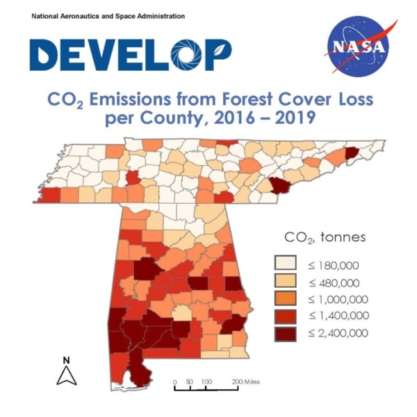 The study, which analyzed carbon dioxide emission trends and tested methods to measure forest cover loss from the years of 2016 to 2019, determined not only that 40,653,060 tonnes of CO2 emissions could be directly attributed to deforestation, as the forest cover could no longer sink carbon dioxide but also which areas of those states had higher levels of those emissions.
That sort of information, along with the methodology developed to attain that information, is invaluable for helping policymakers determine where and how to direct efforts to bring emissions under control and preserve Alabama’s ecology.
This is hardly the first time that such research has proven to be of great value for North Alabama and Huntsville specifically. In 2020, the Huntsville Urban Development Team at NASA DEVELOP published a study which analyzed the effects of Huntsville’s rapid urbanization on the annual Land Surface Temperature (LST).
That study used NASA’s Remote Imaging technology, such as satellite-mounted Moderate Resolution Imaging Spectroradiometer sensors, among many others, to develop a “heat map” of the city of Huntsville. Using this data, the city can then decide where and how to implement green infrastructure projects, which are not only enriching in aesthetic terms, but help break up the “heat island” effects of concrete-and-asphalt urbanization.
Ecological conservation efforts like those undertaken by the Land Trust of North Alabama have impacts on the region that may not be apparent at first glance. The Pollinator Garden at Blevins Gap Nature Preserve, for example, cultivates local wildflower species. This, in turn, creates food and a habitat for pollinating species.
The preservation of pollinating species isn’t important because we love little birds and cute bumblebees – well, not just because we love them – but because the pollination that they provide enable agriculture to function, a function that can be taken for granted until it’s imperiled by the decline in the population of those species.
By applying Space Age tech to the natural world around us, organizations like NASA DEVELOP and the Land Trust of North Alabama empower us to make informed decisions out of enlightened self-interest. And if the birds sing sweeter and the grass grows greener, well, that’s not too shabby either.